Seitenstruktur
-
Spitsbergen-News
- Select Month
- March 2020
- February 2020
- March 2019
- January 2019
- December 2018
- September 2018
- June 2018
- May 2018
- April 2018
- March 2018
- February 2018
- January 2018
- December 2017
- November 2017
- October 2017
- September 2017
- June 2017
- May 2017
- April 2017
- March 2017
- February 2017
- January 2017
- December 2016
- September 2015
- April 2015
- March 2015
- February 2015
- January 2015
- December 2014
- October 2014
- August 2014
- June 2014
- May 2014
- April 2014
- March 2014
- November 2009
- April 2000
- Select Month
| Grytviken |
Home →
Yearly Archives: 2017 − News & Stories
At sea – Februar 17, 2017
Fri
17 Feb
2017
There is a fair and steady breeze blowing around the southernmost corner of New Zealand, the sun is shining, warmly and strongly, the air warmer than I have experienced it for quite some time.
Exactly 100 passengers from almost just as many countries have found their way to our ship, the Ortelius, and everybody is curious what the next weeks will bring. It is the beginning of an Antarctic Odyssey, more than 6000 miles are ahead of us.
Gallery – At sea – Februar 17, 2017
- gallery anchor link: #gallery_114
Click on thumbnail to open an enlarged version of the specific photo.


A light, pleasant breeze is blowing during the first few miles, we have set course south for Campbell Island. Two years ago, we spent more than a day looking at the island in force 10 winds and beyond. Which was, in a way, impressive and beautiful, but going ashore is the real thing. Will it work this time? We are curious, fingers crossed. It would be a dream come true.
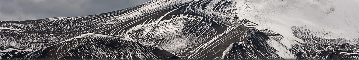
Halley VI: An antarctic research station has to move
In 2012, the British Antarctic Survey had built an ultra-modern research station, on the eastern side of the Weddell sea: Halley
VI. The five previous stations were either covered in snow or not safe to use anymore. Similar to the German research stationNeumayer III, where researchers moved in for the first time in 2009, Halley VI is situated on the shelf ice. Already Neumayer III was perfectly constructed for the prevailing conditions. It should be able to withstand the locally strong winds and drifting snow should not accumulate to the buildings. Since ice is moving, shear forces would act on the construction, too. Fore these reasons the building was erected on hydraulic legs, which gradually could lift it to the level of the current snow layer. However, the German base is fixed to the ice below. At the present location the station is drifting to the shelf ice edge
with a speed of 157 metres per year. The British improved their new construction, and in February 2012, a modular building on ski was ready to move in on the Brunt ice shelf. It can also be lifted hydraulically. Each year, 1.5 metres of snow accumulate due to either snow fall or snow drift. The approximately 150 metre thick ice shelf below Halley VI moves with a speed of more than 400 meters per year. To prevent the loss of the base over the years, heavy vehicles are able to move the individual modules on their ski from its location.
When Halley VI was used for the first time in 2012, several chasms in the shelf ice South of the station were already known. Almost one year later, after 35 years of inactivity, the chasms started to grow again. The crack closest to the station increased by approximately 1.7 kilometres per year. Last October, researchers detected a new fissure in the North. They worried about the station to be cut off from the mainland. Therefore, BAS decided for the relocation of the Halley VI, and the station would not be available for research for 3 years. Within that time, the transfer of the buildings should be
completed. During the Antarctic summer of 2015/16 scientists surveyed the area for a new location and a safe route for transport. It is about 23 kilometres further inland. Camps for fieldworkers and engineers will be build and the first modules are getting on the road during the current summer. The researchers hope that the base will be ready for work for the 2017 summer team. The supply route over the shelf-ice edge would then be extended to 40 kilometres. Better safe than sorry!
Halley VI station on the Brunt shelf ice. Photo © British Antarctic Survey.

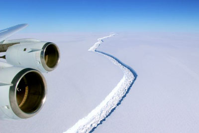
Does the Larsen C ice shelf in the Weddell Sea collapse?
In the beginning of January, British researchers notified on the current situation of the Larsen C Ice Shelf. This ice shelf is located on the East side of the Antarctic Peninsula. A well known and observed crack has grown quickly larger during 2016. The German Alfred Wegener Institute reported about that topic during the last few months on its Ice Blog. Between May and August 2016 the scientists observed an extension of a crack by 25 km. In December this crack expanded another 18 km. The anterior part of the Ice Shelf is now only connected to the remaining Shelf by a 20 km wide “bridge”.
The British Antarctic Survey experts suppose a possible break-off scenario of the approximately 50,000 km² shelf ice area already later this year. In recent years, researchers have given special attention to the “Larsen C” ice shelf. The earlier collapses of the Larsen A (1995) and Larsen B (2002) Ice Shelves had clearly shown one effect: The floating ice acts as a barrier and slows down land based glaciers behind. The loss of such a barrier results in the acceleration of glaciers behind it. Larsen C covers an area about 15 times larger than the 2002 lost ice of Larsen B. Thus it also holds back larger glaciers masses. Two questions are interesting in that context: What causes the break-off of the ice shelf? And what are the consequences of the ice loss?
Scientists have gained a lot of new knowledge about the underlaying processes of the loss of shelf ice during the last years. The collapse of Larsen B was most likely the result of the increased annual temperatures on the peninsula over the past 50 years. During that period of time the researchers have shown an average increase of 2.5 degrees. As a consequence of the warming, the snow layer and the firn layer on the ice shelf vanished more rapidly during summer. Thus melt water ponds evolved more frequently. These lakes froze during winter. Ice of this origin is warmer and softer than the surrounding ice, which has been formed by the transformation of snow to firn to glacier ice. The melt water zones in the glacial ice change the structure of the entire ice shelf. The following summer these zones will start to melt earlier. This effect caused the sudden collapse in Larsen B in 2002.
For the detachment of Larsen C this effect is not the only reason. The results of the BAS studies show a declining firn layer and a decreasing thickness of the snow layer, due to an increased annual air temperature of the area. Further ice loss occurs at the bottom of the ice shelf by warmer water currents. The warming of the earth’s atmosphere and the Antarctic ozone hole strengthen the West wind currents and thus the circumpolar current. This gives enough energy to swash up warmer and saltier water masses from the ocean depths to the continental shelf. The scientists calculated the thinning of the ice to 4 meters, in the period of 1998 and 2012.
What would be the consequences, when Larsen C will disappear? The shelf ice itself has no impact on the sea-level, since shelf ice is floating ice. However, there would not be any other barrier for the land based glaciers behind. They will increase their speed. In the case of Larsen B the surrounding land based glaciers accelerated five times their previous velocity. These glaciers lost a lot of ice, cracked, thinned, and retreated. Meltwater ponds on top of the glaciers, drained into the new cracks and weakened the glacier ice. In a similar scenario for Larsen C, the researchers predict a contribution to the global sea level rise of 50 cm until the year 2100, which will be a challenge for many coastal cities.
Crack in the Larsen C ice shelf. Photo © John Sonntag, NASA.
http://www.nature.com/articles/ncomms11897
Lantern fruits in Antarctica?
Lantern fruits in Antarctica? Tomatoes, potatoes and tobacco from the big ice?
According to the online news section of the magazine Science, US-American and Argentinian researchers have found fossils in Patagonia, Argentina, that belong to the nightshade family, as today’s tomatoes, potatoes and tomatillos.
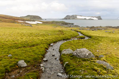
These plants lived more than 50 million years ago in a warm, humid climate, when South America was still very close situated to the Antarctic Peninsula. The Drake Passage did not yet exist. Instead, a shallow shelf sea separated the Pacific Ocean from the Atlantic and South America from Antarctica. At the same time, the border between the subtropical climate zone and the temperate climate zone went across the Antarctic Peninsula. Before the Antarctic continent got covered by snow and ice, it might well have been that these ancient ground-cherries also grew in Antarctica.
With the drastic climate change towards the ice conditions already on the horizon, Antarctica did not become a lantern fruit place. In contrast, it is by far the most hostile continent on the planet and not your place at all if you are a tomato.
Lantern fruits in Antarctica? No, only mosses (Aitcho Island, South Shetland Islands).
Source: Science Daily
News-Listing live generated at 2024/April/19 at 03:32:22 Uhr (GMT+1)
-
Books, Calendar, Postcards and more
-


